Quote of the Day
The gem cannot be polished without friction, nor man perfected without trials.
— Chinese Proverb
Introduction
I find the subject of Antarctica very interesting and I read as much as I can about it – especially articles about the science being done there. I recently was reading an article about Jerri Nielsen, a doctor who developed breast cancer while over-wintering at the South Pole Station (Figure 1), and the difficulties encountered trying to rescue her. As I researched her rescue in more detail, I read a web page that mentioned that the South Pole is limited to a few hours a day of contact with the outside world through satellite communication. I was wondering why this was true and I started to look around the web. I found an FAQ answer that was interesting and worth analyzing here.
Here is the answer on an FAQ that got me curious.
What kind of satellites does the South Pole Station use?
The South Pole Station uses high inclination geosynchronous satellites. Specifically, TDRSS and GOES. Inclination is an orbital parameter that describes the amount of north-south movement a satellite makes in its orbit over 24 hours. When the value is great enough (roughly 8.7 degrees), the geosynchronous satellites are visible at South Pole.
I will show why the satellite's inclination must be about 8.7° for the South Pole Station to communicate with a satellite.
Background
Objective
I want to confirm that a satellite inclination of "roughly 8.7 degrees" will put a satellite right on the horizon when viewed from the South Pole. My analysis will be strictly geometric and I will ignore the effects of refraction. You can include the effects of refraction (example), but it complicates the analysis without providing much additional insight into the problem.
Definitions
- pass window
- The time when a satellite is visible from the South Pole station.
- event
- When the South Pole station uses the a satellite for communications. Events always occur within pass windows.
- ground track
- The projection of a geosynchronous satellites position onto the Earth's surface, which make a "figure-eight" pattern when the orbit is inclined to the celestial equator.
Geosynchronous Satellite Movement
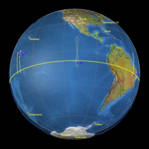
Figure 2 shows how some geosynchronous satellites make a figure-eight ground track over the equator in their orbits.
Remoteness
Figure 3 gives you an idea of just how far away the South Pole station is from everything. I have heard US military folks say that Antarctica is the most difficult logistics challenge in the world.
Analysis
Basic Geometry
Figure 4 shows the geometry of the satellite-antenna situation at the South Pole.
Calculations
Using the geometric picture of Figure 4, I can solve numerically for the satellite inclination that will provide a view from the South Pole.
I compute an inclination value of 8.6°, which is very closely to the value of "roughly 8.7 degrees" stated in the quote.
Conclusion
I was able to confirm the satellite inclination statement made in the quote I located on an FAQ. I now understand why the South Pole Station can only get high-bandwidth data transfers for a limited period each day. I have read that a terrestrial fiber link is in the works for Antarctica, so this problem may be resolved in a few years.
Unfortunately, Jerri Nielsen eventually succumbed to cancer in 2009, but had survived 11 years after her ordeal in Antarctica. Here is her video obituary.


Pingback: Daily Tree Consumption for Toilet Paper | Math Encounters Blog
Hello Algebra